
by Dr. Sarah Treanor Bois, PhD
Director of Research & Conservation at the Linda Loring Nature Foundation
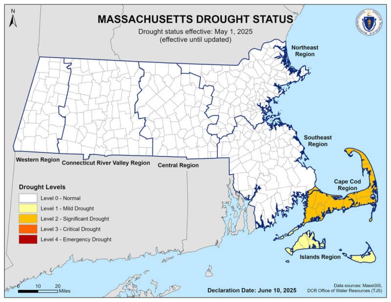
Last week, Nantucket was placed under a Level 1 drought by the Massachusetts Drought Management Task Force, prompting mandatory restrictions on outdoor water use. Then, over last weekend, we learned that the town’s primary water pump suffered a mechanical failure, leaving the island’s water storage tank at “critically low” levels. The ensuing water use ban has included all non-essential water use, and applies only to properties connected to the municipal water system.
As an island surrounded by water, we don’t often think about our limited freshwater systems. How prone are we, on Nantucket, to these drought conditions?
While the Northeast is generally considered a moist region, droughts, including “flash droughts,” are not uncommon. Massachusetts actively manages drought conditions through a Drought Management Plan and monitors conditions using various indices. As recently as November of 2024, most of Massachusetts was under a Level 3—Critical Drought designation, but the Cape and Islands were exempt from that distinction. At that time, the drought was driven by unprecedented low rainfall over several months, which led to dried streambeds, critically low groundwater levels, and environmental challenges that affect ecosystems, water supplies, and fire safety. Nantucket was exempt at that time, but, as evidenced by our recent designation, we are not immune.
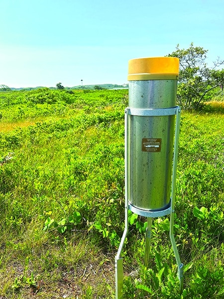
Low rainfall is one of the primary initial causes of drought. To help us understand precipitation patterns on Nantucket and how they fit into the bigger regional and national pictures, the Linda Loring Nature Foundation (LLNF) became a precipitation center for the island, monitoring multiple aspects of our precipitation with different and complementary projects. Since May of 2014, we’ve been taking daily precipitation measurements as part of the Community Collaborative Rain, Hail, and Snow Network (CoCoRaHS). This community science network was started by the Colorado Climate Center at Colorado State University in 1998. The strength of this data set lies with hundreds of monitors collecting data with the same exact rain gauge using the same set of standard protocols in all 50 states. The data collected are then publicly available for anyone to use via their interactive website. Aside from curious citizens, the data are used by the National Weather Service, other meteorologists, hydrologists, emergency managers, insurance adjusters, and the USDA, among others.
Many of us have had the experience of talking to someone in Madaket where it’s raining and being in town where the streets are still dry. The more rain stations, the better! With the CoCoRaHS program, anyone can establish a gauge. There are currently 10 CoCoRaHS stations on the island, though not all regularly record precipitation. You can check out summary info for the LLNF station here: dex.cocorahs.org/stations/MA-NT-1 .
LLNF also collects daily precipitation data for the National Oceanic and Atmospheric Administration (NOAA) as part of their Cooperative Weather Observer (COOP) program. LLNF became an official climate site in 2017 when we became a COOP station. Through the COOP program, more than 10,000 volunteers take daily weather observations at National Parks, seashores, mountaintops, and farms as well as in urban and suburban areas. States based on the ideas of Thomas Jefferson. Because the network’s observers have generated consistent long-term historical climate data, the network has established an instrumental record of climate. Climatic atlases for the country are based on decades of observations from COOP observers. These data are invaluable in learning more about the floods, droughts, heat and cold waves affecting us all. COOP data plays a critical role in efforts to recognize and evaluate the extent of human impacts on climate from local to global scales. The LLNF COOP site adds to this historic data set and help create more accurate weather predictions for the island.
Of course, drought is more than just lack of rainfall. And what does it mean to “recharge” our public water supply?
Nantucket’s sole source aquifer is where we get all our freshwater; both the public water system and private wells. This glacial aquifer relies on rainfall filtering through the island’s sandy soil. The aquifer is abundant but not unlimited. Private wells draw from the aquifer, but so does the Wannacomet Water Company, Nantucket’s public water provider. Which draws on the aquifer from five wells. According to the Town’s website, two wells pump groundwater from a shallow aquifer at about 75 feet, while the remaining three wells pump groundwater from a deeper aquifer at about 150 feet. The Siasconset Water Department (also part of the public water supply) serves a small portion on the eastern end of the island drawing from two wells in that area.
The level one drought conditions alone wouldn’t be a huge cause for alarm regarding the aquifer. With the water pump issues being exacerbated by the drought conditions, we all need to work together to conserve our precious water resources. There are, of course, mandatory restrictions prohibiting “non-essential” water use (https://www.nantucket-ma.gov/1313/Nantucket-Alert). There are also recommendations for water conservation like delaying laundry and dishwasher loads or taking shorter showers. At the time of this writing, the pump has been fixed, but we know this problem isn’t going away anytime soon.
Droughts have always been a part of natural climate cycles; however, humandriven climate change exacerbates their severity. Rising temperatures increase evaporative demand, which means the atmosphere pulls more moisture from water bodies, soil, and plants. This phenomenon transforms moderate droughts into severe ones. Recent studies have shown that warming trends make droughts last longer, cover larger areas, and cause more significant environmental harm. So we should expect more drought conditions and the accompanying water restrictions in the future.
The COOP program is the nation’s largest and oldest weather network. It was established in 1891 to formalize the collection of meteorological observations and record climate conditions in the United