by Dr. Sarah Treanor Bois, PhD
Director of Research & Conservation at the Linda Loring Nature Foundation
The Madaket Ditch…it doesn’t have a very sexy name, but it is one of the most fascinating and vital parts of the western end of our island. For something so essential to the water quality of Long Pond, it is an often-missed feature of the landscape. Most islanders and visitors have never even seen it.
This is actually a story of landscape legacy effects, how alterations to the land can still be seen 350 years later. It starts with two groups of people altering the landscape to sustain themselves. And what was human-created centuries ago is now part of the island’s cultural heritage.
The Madaket Ditch is a human-created tidal creek that runs east-west, connecting Long Pond on the east side to Hither Creek on the western end. The Ditch is about a mile long and is mostly straight, though there are a few hitches and meanders along the way.
The Madaket Ditch and the connection to Long Pond changed the system from a freshwater pond to a brackish, tidally influenced body of water. The anadromous fish migrate into these waters in the spring to spawn (shad, alewives). The catadromous fish (American eels) migrate the opposite direction, heading out to sea to spawn. Madaket Ditch has turned the Long Pond watershed into one of the true estuaries of Nantucket Island.
So where did the Madaket Ditch come from and who built it? According to town records, in 1659, an agreement was struck between the English settlers and the native Wampanoag. Of course, we know who wrote the history, so we must take this with a grain of historic salt. According to a document with the Nantucket Registry of Deeds (later translated by Elizabeth Little in 1986), the agreement was struck between the two parties to dig a “trench to drain the Long Pond.” This trench would serve two purposes: for fishing and for the creation of a salt meadow. The work was to be divided equally between the “English Inhabitants” and the Wampanoag, and they would split the spoils that resulted from their work with one caveat: “So long as they (presumably the Wampanoag) attended the weir carefully and honestly.”
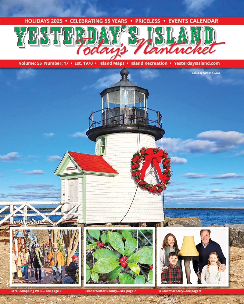
The fishing weirs were a series of framed nets that crisscrossed the ditch to capture the running migratory fish. This method was adopted from the Wampanoag methods. In fact, the Wampanoag had shared knowledge of the life cycles of eels and alewives with the newly arrived English settlers. Once dug, the ditch would bring more fish further inland, thus creating more fishing habitat and increasing the resource.
The ditch was dug in 1665, six years after the original agreement was struck. What I haven’t found in my (limited) research so far is anything about how the ditch was actually dug. Did the two groups start on opposite sides and work towards each other? Did they start in the middle and work towards the respective water bodies? Was it truly collaborative with mixed work crews? Who was in charge? How was the start and end point decided? At this point, there are almost more questions than answers.
What we do know is that it was a success. Or, at least, the original goals were achieved. Fish weirs were constructed, and fish were caught. The salt marsh habitat (i.e. the desired salt meadow) was expanded and salt hay (the saltmarsh grasses) was harvested for sheep fodder. However, the success was limited, at least for the Wampanoag. In 1676 the property rights along the ditch were transferred to the proprietors (the English leaders), and fishing rights were taken from Wampanoag. But the Madaket Ditch continued to be productive.
Over time, the Madaket Ditch remained an important fishing source for islanders. In 1841, the Town widened the ditch and set fishing regulations. In the late 1800s a committee was formed, and the Lond Pond and Madaket Ditch Report was submitted by the Committee at the Annual Town Meeting in 1882. The report stated that the Ditch had become clogged. After a lengthy discussion, the question was raised about whether the Town of Nantucket allocated the necessary funds to clear it. Also discussed was the issue of ownership of Nantucket ponds. That story is for another day, but this article by historian Frances Karttunen written for the Nantucket Historical Association details some of the legalities nha.org/research/nantucket-history/history-topics/what-was-the-hot-topic-fornantucket- government-in-1882 .
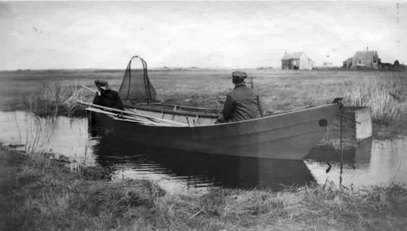
Well into the twentieth century, harvesting of herring and eels was conducted by dip net and eel spear along the banks of the Ditch. There are many tales of island families ice fishing for eels in winter in Hitcher Creek or points along the Madaket Ditch. Herring are now protected with a moratorium in place on their harvest, but the Ditch remains active.
In the intervening decades, Madaket Ditch has been dredged, widened, and expanded via offshoot trenches. While there is no current plan for dredging the Ditch, there have been some recent calls to do so. The Nantucket Coastal Resiliency Plan (adopted by the Town in 2021) calls for raising of Madaket Road, potentially increasing culverts, and overall ecological restoration to the are—a plan that could also involve improvements to the Ditch.
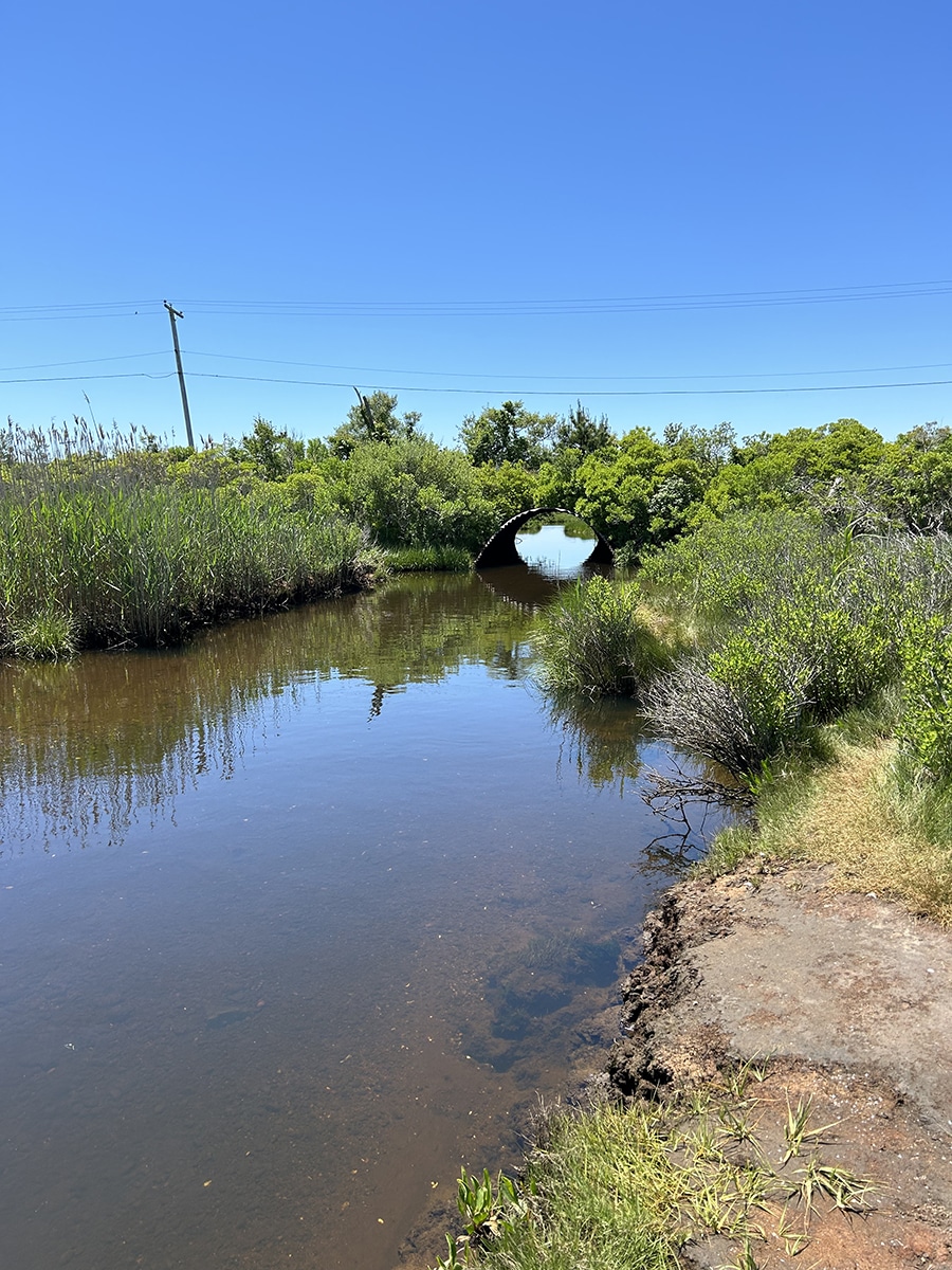
Today, the Madaket Ditch is one of Nantucket’s only true functioning estuaries. It functions like a tidal creek, connecting Madaket Harbor and Hither Creek all the way to Long Pond. The narrow, sometimes meandering channel still brings saltwater into Long Pond with each tide and flushes water out on the outgoing tide, thus flushing Long Pond at regular intervals four times a day. The ditch now runs through approximately 50 acres of functioning salt marsh, which serve as a nutrient sink for the pond. The marsh intercepts an appreciable amount of nutrients before they reach the creek and the harbor. It is estimated that it takes 76 days for the whole of Long Pond to turn over completely via tidal exchange. Without the Ditch, many wonder what the water quality of Long Pond would be like. Other Nantucket ponds, Sesachacha and Hummock, are episodically opened to the ocean manually. Long Pond is our only Great Pond that is connected to the ocean consistently—a true estuary.
At a time when salt marshes are prized for their ability to filter water and to protect uplands from storm surge and other impacts of climate change, how can we say that the long-ago alteration of habitat is a negative?
In 2023, the Linda Loring Nature Foundation initiated a project to look at the tidal flow of the Long Pond watershed. That study is on-going, but more people caring about and investigating this estuary is always a plus. The Town of Nantucket takes regular water quality samples from the estuary, and the full report looking at trends over the years can be found here on the Town’s website: nantucket-ma.gov/723/Harbors-Ponds. The Nantucket Conservation Foundation included the Madaket Ditch in their American Eel study (2024-present) involving community members in learning more about our cultural heritage, the water bodies, and the eels.
Access to Madaket Ditch is somewhat limited. Much of the land surrounding the Ditch is private with conservation easements, thus protecting the integrity of the ditch. Sections are owned by various conservation organizations including the Town, Nantucket Land Bank, and the Madaket Conservation Association. The Land Bank properties towards Hither Creek are the public’s best bet for getting to the Ditch.
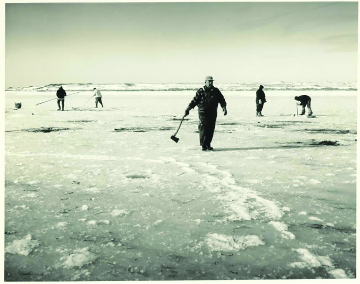
This spring, the Linda Loring Nature Foundation, in collaboration with the Nantucket Land Bank, ran several public programs about the Ditch, its ecology and history. Every single field trip filled to capacity, suggesting that people are interested in this unique aspect of island life. We hope to run more of these field trips in the fall of 2025.
It’s on my personal summer bucket list to navigate the Ditch via kayak. I’ll certainly record the journey when I do.