
by Dr. Sarah Treanor Bois, PhD
Director of Research & Conservation at the Linda Loring Nature Foundation
For many of us, Coatue is the sandy stretch we seek out to get away from the rest of Nantucket. Whether by boating across the harbor, kayaking, or traversing the over-sand paths by vehicle, many of us recognize that this place is special. Wild landscapes, nesting bird life, great fishing…it’s a wild place that brings us back in time. Even so, it might also be a place we sometimes take for granted. We might enjoy it for the escape, but how often do you think about how vital this barrier beach is to our island way of life?
The Coatue Wildlife Refuge is a unique and pristine environment which contains more than 395 acres of barrier beach that defines Nantucket Harbor, sheltering it from Nantucket Sound. Collectively, the Coskata-Coatue peninsula is 1,171 acres part of which is Coatue beach. Within the area of Coatue is a diverse mix of habitats, including the barrier beaches and dunes, the marine intertidal, and vegetated uplands. This barrier beach buffers the town and the surrounding infrastructure from intense storms and wave energy. It is the narrow band of vegetated sand that keeps the harbor waters calm and provides protection for our harbor and the land to the south.
When we think of barrier beaches, offshore sand islands sometimes come to mind. These barrier beaches typically run parallel to the shoreline. For most of the US, that means they run north-south. Think of the Outer Banks, NC or Assateague Island, VA. These beaches act as natural barriers, absorbing the energy of waves and storms, thus protecting the mainland and its associated ecosystems.
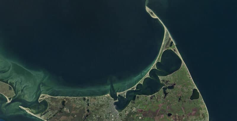
On Nantucket, our barrier beach is unique in that it runs diagonally west to east, curving northward towards Coskata and Great Point. This orientation is parallel to the two opposing wind directions, the dominant northeast and prevailing southwest, which results in the unique shape of this landform. Anyone drawing a quick sketch of Nantucket (even our kindergarteners at Nantucket Elementary School) includes the tip of Great Point followed by the long peninsula with teeth along the bottom. These “teeth” or points are the cuspate spits of Coatue.
Cuspate spits are curved projections of beach into the enclosed harbor shaped by wind and wave action. The cuspate foreland is the north side of the barrier beach open to the ocean that gets the brunt of the wind and wave action. Coatue’s southern shore has six curved sandy points or “spits.” Viewed from above, they look like a serrated knife or the edges of a scallop shell. The foundation of the Nantucket barrier beach system, including these cuspate spits, was laid more than 20,000 years ago by sand deposits from glaciers.
It has been said that “The sand resembles the rhythm of waves,” and that’s not too far from the truth. The cuspate spits are a product of the interplay between wind, waves, and tidal action. There are three key coastal processes that work together to create and maintain the cuspate spits. The first is an ample supply of sand. The second is the harbor’s long axis alignment with seasonal wind and wave action. The long axis of the harbor is parallel to two opposing wind directions, the dominant northeast and prevailing southwest, causing nearly equal longshore transport of sand in opposite directions.
The third, and perhaps most unique aspect is the “tidal amplitude.” The specific tidal amplitude in Nantucket Harbor—low enough to form barrier beaches but high enough to erode spit tips—is crucial for the creation and maintenance of these formations. This trifecta of conditions maintains the spits at equilibrium. They each depend on the other in a self-organized system.
In his 1975 paper studying Nantucket’s cuspate spits, Peter Rosen described the formation:
“Sediment is eroded from each of the concavities between the cuspate spits and transported to the spit ends, where it is deposited as subaqueous bars. These bars are eroded by the tidal currents, which act as the destructive agent of the cuspate spit-shoreline reorientation process. The tidal currents and opposing longshore drift have resulted in an abrasional shoreline approaching dynamic equilibrium.”
To put it plainly, sand is eroded from the curves and deposited on the points. In contrast, tidal currents flowing in and out of the harbor erode sand from the points and deposit it back into the bends. These opposing forces have been in equilibrium for hundreds of years, creating a world-class example of the rare geologic feature that has improved scientists’ understanding of coastal ecology. This formation is so unique that coastal scientists around the world study our six cuspate spits, which are also lauded for being free of development or engineering. A lasting cuspate spit formation is so unusual, it is only found in one other place in the world: in the Chukchi Sea lagoons of northeastern Russia, though these formations differ with the cuspate points pointing northward.
The cuspate spits of Nantucket persist as they are allowed to follow natural patterns and processes. That now begs the question; what if these processes are disrupted? It is speculated that loss or disruption to any part of the process will alter the existence of this rare coastal feature.
The cuspate spits are so unusual, in fact, that in 2024 the Coatue-Coskata complex, which also includes Great Point, was deemed a National Natural Landmark by the U.S. Secretary of the Interior. The Nantucket cuspate spit series are considered “globally rare.” Already protected by the Nantucket Conservation Foundation, the Trustees of Reservations, and the US Fish and Wildlife Service, this National recognition further protects the habitats and encourages more research and understanding of the geological heritage.
According to the National Park Service, landscapes are chosen for this recognition because of their “outstanding condition, illustrative character, rarity, diversity, and value to science and education.” Having this designation could also help NCF and the Trustees with potential grant funding in the future. With the threat of sea level rise, increased storms, and storm surge, more may need to be done to protect the vital and unique habitats. A potential breach of this system could have devastating consequences for the Town and for our way of life.
Nantucket’s cuspate spits offer a tangible link to our dynamic geological past and continue to play a crucial role in shaping its present and future.
For more information about this unique habitat and the potential threats, check out the 2024 video, Coskata-Coatue: A Refuge on the Edge found online at nantucketconservation.org/what-we-protect/properties/coatue/