Shifting Sands
by Aaron Marcavitch
OK, I will admit it. I am a bit of a model railroad geek. Maybe more than a bit. The only thing holding me back from really making a big layout here at home is the space (and the desires of my dear wife). When we first moved here I asked the question “was there ever a railroad here” and got back the a positive answer – to my great surprise. I was even more surprised that everyone seemed to regard it with a bit of pride. So I started to research it.
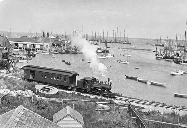
Photo courtesy Nantucket Historical Association
It turns out that the railroad ran from 1881 to 1918. It ran basically at the same time as my hometown railroad (the Waynesburg and Washington Railroad) and they turned out the same way – narrow gauge. Maine is very proud of their three-footers. Georgia had loads of them too. Really, any place that was thinking about trains in the 1870s was thinking about three-foot narrow gauge tracks. (Normal railroads run on a track spaced 4'-8 ½ inches apart. Various rumors place this size as the size of Roman carts, but in actuality it was just a size determined by an early inventor of the railroad engines. Truthorfiction.com says that “Interestingly, the 4-foot, eight-and-a-half inch width has not always been the standard in the U.S. According to the Encyclopedia of American Business History and Biography, at the beginning of the Civil War, there were more than 20 different gauges ranging from 3 to 6 feet, although the 4-foot, eight-and-a-half inch was the most widely used. During the war, any supplies transported by rail had to be transferred by hand whenever a car on one gauge encountered track of another gauge and more than 4,000 miles of new track was laid during the war to standardize the process. Later, Congress decreed that the 4-foot, eight-and-a-half inch standard would be used for transcontinental railway.”)
The line was originally planned for a northern route up along the cliff. However, after much discussion it was placed on a southern route. It started at Steamboat Wharf, ran through the salt marsh to the south and across Orange Street extension. It continued across more marsh and ran through the farms of the (now) mid-island. It specifically crossed through Hooper farm and eventually routed itself to Surfside. Peter Schmid wrote in the 2000 issue of Historic Nantucket “To further entice people to ride the rails, a depot and restaurant opened at Surfside in July of 1881, and it was estimated that by the end of the first season the train had carried over 30,000 passengers and traveled nearly 6,000 miles. The first trains were made up of an engine and several open sided train cars. Surprisingly, the open sided cars like the ones we see at amusement parks were more common at the time than we might expect.
Much like the resistance to our bus system encountered on a regular basis today, the train line experienced much of the same. Tourists loved the ride, locals thought it might destroy their trade. However, after the first year everyone started to recognize the importance of the line. A major hotel was built in Surfside. Developers started the Surfside Land Company. Again Peter Schmid writes that “[the land company had a] realty office in the depot and sold nearly 180 lots by the end of 1882. The railroad, along with willingly offered capital and speculation, had made Surfside a resort destination. But the railroad did not stop there.”
By 1884 the railroad began the process of finishing the line to Sconset. It ran over the edge of the island through what is now Tom Nevers. It wrapped around the edge and ended just below the bluff in Sconset. If you cross under the bridge in Sconset and look to your right will be the site where the trains stopped. A small station was built at the base of the bluff.
The line went through various problems with the shifting sands of the south shore. The railroad had to constantly re-build the line along the coast. Every year was another rebuilding effort before the opening of the tourist season. In Consue Springs, then the salt marsh, the engineers had to constantly re-open the right-of-way. The built bridges and culverts to keep the water flowing under the tracks and not wash it away. However, each winter brought another wash out somewhere along the line.
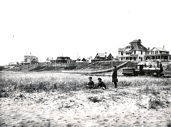
Photo courtesy of Nantucket Historical Association
In 1895, the line was rerouted. It still ran from Steamboat Wharf, along Washington Street, and across Orange Street, but instead turned along Sparks Avenue toward (what is now) Fairgrounds Road. Of course, at that time the fairgrounds (also known as the Agricultural Society grounds) was located at the corner of Old South Road and Fairgrounds Road. From here the line ran through the airport's current location. It cut down the middle of the island and eventually returned to the crossing at Tom Nevers Head. The railroad abandoned Surfside — the hotel and realty group both went bankrupt. (Lots were sold at $2.80 a piece by the end.) However, Tom Nevers became the new hot spot. Even today we can see the remnants of that land speculation. Look at any assessors map and you can see the little tiny slivers of land that make up Tom Nevers. There was a Tom Nevers Lodge, a club, speculation brochures, and long streets laid out (with names from the North End in Boston).
Approaching Sconset the railroad straightened out a bit and rolled across the beach. Some of the more interesting pictures of the trains is shown at Sconset. One image shows a train possibly carrying lumber or timber. This is one of the few indications that the line carried more than passengers or mail. From this point the train had to run backwards toward town. There was a turn table and engine house in town, but it required the train to run all the way back to town to use them.
Images of the railroad show the small stations as little vernacular structures. The structures had long overhangs for passengers but were little more than sheds. Surfside station, however, was a bit more dramatic. The trains were simple too. As a seasonal railroad it was critical to keep overhead low, so the company bought second-hand equipment, often with dramatic failures. By the last parts of the history they were running a little gas powered shuttle called the Bug that towed a little delivery wagon called the Bird Cage.
Eventually the shifting sands took their toll. In 1918, trains were scrapped and the engines sent to the war effort. Local lore says that one engine that derailed is buried under Washington Street, around where the town annex building is located. The last remaining car was integrated into the Club Car restaurant. Little more than that remains.
You can experience some of the trainline by walking the right-of-way through the marshes at the end of Washington Street. Hatch's package store sits on reclaimed land from the railroad. The slow curve of the railroad still shows up on Station Street in Surfside. Near Tom Nevers Head the right-of-way still crosses the marshy area. Unfortunately the shifting sands have taken various parts of the railroad layout. Some local collectors still find spikes, but for the most part its been picked over. We can still look at the images of the trains and marvel at a time when the island looked much more industrial. It was a place where the trains ran over shifting sands fighting to stay alive.