• by Dr. Sarah D. Oktay, Managing Director UMass Boston Nantucket Field Station •

Barrier beaches protect lagoons, estuaries and salt marshes from the direct action of the sea. There are three kinds of barrier beaches. Bay barriers form between two adjacent headlands. The lagoons that are created by bay barriers may in time become freshwater ponds if the beach is not breached by the sea. This barrier is most common along the rocky coastlines of New England and Canada. The spit of land between Sesachacha and the ocean is an example of this type of barrier beach. You can see lagoons becoming enclosed fresh water ponds. Nantucket’s original harbor, Capaum Harbor, is now an enclosed pond bounded on the north by a barrier beach. Hummock Pond and Miacomet are protected by barrier beaches. These beaches do get breached in the larger storms and the Nantucket Field station barrier beach was severely breached during Hurricane Sandy and Nor’easter “Nemo”. Old pieces of a wrecked schooner and long buried student beach grass projects were unearthed in the erosion that took place at the field station with 3-4 feet of barrier beach height and 10 feet of width erased in the storms. You can see pictures and learn more about how barrier beaches project salt marshes at http://cnnradio.cnn.com/2012/11/02/cnn-profiles-sandys-nantucket-warrior/.
Barrier spits form where materials carried from a headland but currents, build a sandy “arm” into a bay or sound. Sandy Hook in New Jersey and Cape Henlopen in Delaware are examples of barrier spits. Local barrier spits include Smith’s Point, Eel Point and Whale Island on Tuckernuck.
Barrier islands are the third type of barrier beach. They are long, low, usually narrow islands with inlets to the back bay waters at either end. Barrier islands form a nearly continuous chain from New Jersey to Mexico. I lived for many years on the barrier island of Galveston Texas.
In their natural state, free to move and react to the whims of the sea, barrier islands provide invaluable protection to the mainland. In the calm waters behind barrier islands, salt marshes, the most productive of all ecosystems, are able to develop and thrive. Barrier islands provide important habitat for many species of plants and animals. Left to the forces of nature, barrier islands are one of the most beautiful of all landscapes. Barrier island also tend to migrate toward the mainland by eroding on typically their high energy side (whatever direction fasces the largest waves and ocean) and filling in on the low energy side. Barrier beaches such as Galveston and the long spits that used to lie to the south of Tuckernuck eventually join up with their “downwave” in this case northerly larger land mass.
From the Nantucket Conservation Foundation’s excellent new website (www.nantucketconservation.org):
“Nantucket’s barrier beaches occur at the interface between the island and the surrounding sea. Coatue, Great Point, Coskata and the Haulover collectively comprise an ever-changing fragile strip of sand that shelters Nantucket Harbor from the open waters of Nantucket Sound and the Atlantic Ocean. These beaches have been deposited and reshaped over the last 6,000 years by ocean currents moving sand northward in a process called littoral drift, forming Nantucket’s northernmost place – Great Point. An east-west current called long shore drift transported and deposited sand in a similar process to form the adjoining barrier beach known as Coatue. Smaller barrier beaches also occur at Smith Point and Eel Point, on the southwest and northwest corners of the island.
American beach grass is the most common plant found growing on the beaches of the Northeast. It forms an extensive network of underground stems. These rhizomes send up new shoots that hold windblown sand in place and promote the formation of new dunes. In the more protected areas behind the dunes, low shrubs that are able to grow under nutrient-poor conditions serve to further anchor the sand. Salt-spray rose, bayberry and beach plum are salt-tolerant shrubs that shed their leaves annually, adding nutrients to the sand as they decay. As the soil becomes more stable and enriched, other species such as eastern red cedar, black huckleberry and low-bush blueberry are able to colonize these areas, resulting in a diverse interdune plant community. Several rare and unusual plant species occur on the island’s dunes, including the prickly pear cactus, oysterleaf and pink lady’s slipper.”
Last week we talked about some basic facts about erosion and beaches and dune. Entire books can and have been written about coastal geology and coastal processes. Today I thought I would try to answer some common questions about beaches and erosion.
Erosion and Beach Q&A: (below I have listed a few frequently asked questions- we could go on for days on this subject alone, but I’ll stop at four questions)
For years we have been putting Christmas trees on the shore to collect windblown sand. Is that a good idea?
In areas devastated by Hurricane Sandy in New Jersey, people are stockpiling Christmas trees and using them to augment dunes and beaches. The idea is not the world’s worst and the same tactic has been used on Nantucket over the years. Even the Department of Environmental Protection in NJ advocates for use of trees in small pilot projects. But coastal engineers and beach experts warn that these dunes are not as stable as naturally grown dunes made by beach grass plugs or even sand drift fencing. When a storm pulls out a Christmas tree beach, it tends to remove the whole structure and Christmas tree can prevent natural beach grasses from reestablishing. They are also fire hazards and can introduce invasive plants. The states of Delaware and Massachusetts and no longer advocate for the use of Christmas trees for the above reasons.
“Over the years we have learned that this practice does not help as well with established dunes as the use of native vegetation and sand fencing and it can smother existing beach grass. We have also learned that dead trees and brush are fire hazards that can lead to the destruction of established dunes.”
The December 2008 Marine Extension Bulletin published by the Woods Hole Sea Grant & Cape Cod Cooperative Extension entitled “Coastal Dune Protection and Restoration: Using “Cape” American Beach Grass and Fencing” (found at http://www.whoi.edu/fileserver.do?id=87224&pt=2&p=88900) also mentioned Christmas trees, but not in a good holiday way. They remind us that “Discarded Christmas trees are not effective in maintaining a coastal dune under storm conditions. It has been shown that storm waves dislodge the buried trees, rapidly removing all accumulated wind-blown sand.” But having said that, many communities in New Jersey and New York that survived Hurricane Sandy relatively intact did it with the help in some case of long buried Christmas trees!
Why is the sand different colors on the beach?
Beach sand is composed of a number of different minerals. Clear, glassy grains with uneven fractures are probably quartz. This mineral comes in several shades from clear to gray and black. Milky red, pink or white grains are usually feldspar. Glassy black or clear flakes are made up of mica. Most of the dark grains are varieties of hornblende. All beaches reflect the material of their parent rock and tend to become sorted in size based on the waves and energy of the beach. Higher energy beaches have coarser particles, up to the extremes of rocky beaches in which all smaller sand has been removed. Fine beach sand can only exist on beaches with gentle waves or extensive breakwaters.
What is the difference between a jetty and a groin?
Come on either graders, get your mind out of the gutter! A jetty is a large version of a groin built out into the ocean, on one or both sides of an inlet, to keep the inlet from filling with sand. Jetties, like groins, can create problems as well as provide benefits. Sand will build up on the “upcurrent” side of a jetty or groin because it is trapped by the structure, but sand will be scoured or removed on the “downcurrent” side because the longshore transport has been interrupted. There will always be beach erosion downdrift of the last groin. The point of jetties is to protect a major channel by minimizing shoaling and sand transport across the inlet between each jetty. But even inlets with jetties need periodic dredging. Groins are normally built to interrupt the transport of sand while jetties are built to protect a navigation channel or to keep a river or estuary from naturally meandering. One of the best sites on the web to learn about beach processes is Beachapedia which can be found out http://www.beachapedia.org/.
Why do we have to stay off the dunes?
Planting ‘Cape’ American beachgrass (Ammophila breviligulata) is the most effective way to stabilize existing dunes and build new dunes along our coastline. This vegetation is easy to plant and it spreads rapidly. It reduces wind velocity near the ground and traps windblown sand around the grass. As the sand deposits accumulate, the grass grows up through it maintaining a protective cover. This grass is not very tolerant of vehicle passage or people trampling it, so stay off those dunes! Beach grass is designed to snap off at the base, so only a few steps can result in beach grass dying, being blown out by the next storm and creating bald patches. From the National Park Service Guide’s Guide to Cape Cod Beaches (http://www.nps.gov/caco/planyourvisit/upload/FinalGGCoastal.pdf ) “Beach grass is the creator and guardian of our sandy beaches and dunes. It is a perennial, tough, native grass that can withstand some flooding, salt spray, drought, strong winds and accumulating sand. It is the first plant to be seen growing on a forming sand dune. Bits of broken rhizome from the beach grass root system will start growing with little moisture. This is why beach grass grows back so quickly after a storm has torn it to pieces or buried it completely. When a healthy stand of grass develops, the stems break the force of winds and blowing sand. Grains of sand come to rest at the base of the stem and a good stand of grass can accumulate up to four feet of sand in a year’s time. This natural system is more effective than artificial methods for dune building and rebuilding. When the root system of the grass is exposed, one can see clearly that the clumps of grass are connected to each other by underground horizontal stems, the rhizomes. These horizontal rhizomes have enlargements from which grow tough wiry roots that spread out into the sand. As the grass is buried and grows up, decaying parts of the grass create humus so other beach plants can take hold and grow. It is best not to walk on the grass with shoes, and not slide down or climb up a dune face. Wherever beach grass is destroyed, the dune begins to disintegrate and blow away.” By the way, this guide is an excellent source of all kinds of information on Cape Beaches. This site emphasizes that replanting beaches and dunes is the best way to protect land behind the dunes.
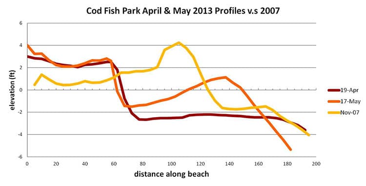
And last but not least I have included the graph from Max Duce and Stefan’s beach profiling report that did not make it into last week’s column. With this two part article I have created a virtual and as you can see from the graph itself, actual cliff hanger, get it?